Race planning for unsupported ultras

Nobody hands you a bottle at 3 a.m.

RYDN turns a race GPX into a plan you can trust: where the water is, when you’ll get there, and whether it’s still open when you do.

Closed beta, free while it runs. I let riders in by hand, batch by batch. Or continue with Apple or Google.

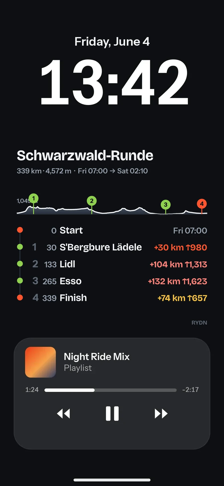
Lock screen made by RYDN, below the phone’s clock: the race name, the elevation profile, and the next stops with kilometre, distance and climbing
  • Your clock stays where it is. The plan sits below it.
  • The race at a glance. Next stops with kilometre, distance and climbing.
  • Music keeps its place. Wake the phone, read, ride on. No unlocking, no signal.
One real route, start to finish.A 339 km loop through the Black Forest with 4,572 m of climbing. Every number on this page comes out of the app.
57 kmlongest gap between two places to refill
7stops checked by hand before the start
5stops in the final race plan
19:11 hto the finish, Saturday 02:10

One route, five stops, from the GPX to the ride.

You could do all of this with a map, Street View and a spreadsheet. RYDN does the searching and the arithmetic, and leaves the judgment to you.

Stop 1 of 5 · km 0

Load the GPX.

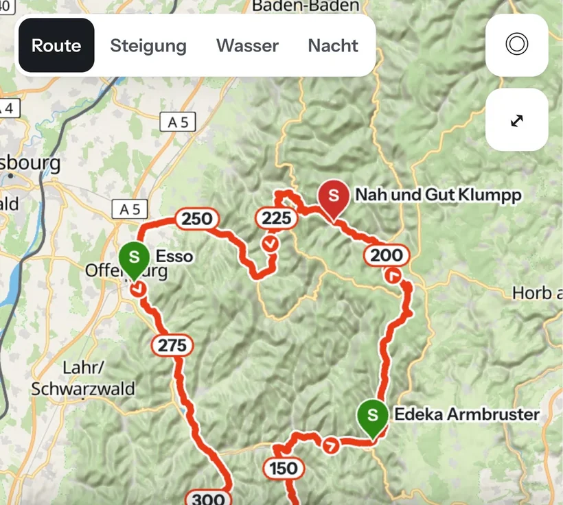
Distance, climbing, and a map that shows terrain, rivers and towns instead of a bare line. Your file is never changed, so the track on your head unit stays exactly the organiser’s.

  • 339 km, 4,572 m of climbing
  • Every checkpoint from the file
  • Works on the phone
The race map in RYDN with the route through the Black Forest, kilometre marks and the planned stops as pins
Stop 2 of 5 · km 30

Find water and food.

RYDN searches OpenStreetMap within 500 m of your route: fountains, vending machines, bakeries, shops, and fuel stations that actually have a shop. Grouped by type, so the long dry stretches show at a glance.

  • Within 500 m of the track
  • Longest gap on this route: 57 km
Found within 500 m of the 339 km route
Shops
188
Fountains
104
Fuel stations with a shop
54
Vending machines
37
Stop 3 of 5 · km 133

Verify. Don’t guess.

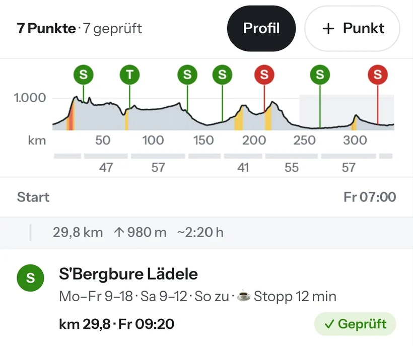
A pin on a map is a candidate, not a promise. Each place opens in Street View or Google Maps with one tap. Tick it if it’s there, cross it if it isn’t. Only checked stops count as reliable.

  • Street View at the exact spot
  • Opening hours from the map
  • Checked stops stay checked
Seven stops on the elevation profile in RYDN, and the first stop with its opening hours, arrival time and a green checked mark
Stop 4 of 5 · km 265

Plan the race.

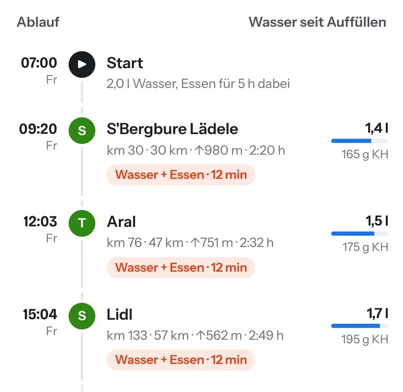
Arrival time at every stop, computed from your power, your weight and the terrain. RYDN stops only where your water or food would run out, flags shops that are closed when you arrive, and shows the same plan as fast, balanced or careful.

  • 5 stops, 2 skipped as closed on arrival
  • Time in the dark
  • Climbs with the steepest 100 m
The race timeline in RYDN: arrival time at each stop, what to refill there, and the water needed for each leg
FinishSat 02:10Start Fri 07:00
Total time19:11 hriding and stops
Riding
18:11 h
avg 18.6 km/h
Stops
1:00 h
5 stops, 12 min each
In the dark
4:36 h
from about 21:30
Sleep
0:00 h
straight through
The same plan, three ways
FastSat 01:05−1:05 h
BalancedSat 02:10your values
CarefulSat 03:53+1:43 h

Balanced uses your power (140 W) and your stop times.

Stop 5 of 5 · km 339

Take it with you.

A lock screen per race day for your phone, and the original GPX with every stop as a waypoint for Garmin, Wahoo or COROS. Out there you need no signal and no app.

  • Lock screen per day
  • Waypoints with km and opening hours
  • Cue sheet as CSV
The lock screen from RYDN on a phone: clock on top, the race plan in the middle, the music player below
That is the whole preparation.Want it for your next race? The beta is free.

Software suggests. You decide.

A shop on a map might be closed for good. A fountain might be dry. RYDN never dresses up a guess as a fact, and it tells you what it doesn’t know.

SuggestedFound on OpenStreetMap or added from a town along the route. Shown, but not trusted.
VerifiedYou looked at it and confirmed it, with the source and the date. Counts for water gaps and the plan.
Ruled outDoesn’t exist, or you don’t want to rely on it. Stays out of the plan and the export.
Jakob riding a loaded gravel bike on a dusty road
Built by one rider, not a company.

I’m Jakob. I built RYDN for myself, to prepare for The Capitals 2026 by PEDALMA. It helped me find and verify my stops, so I made it public for other riders.

Photo: Cesc Maymó / PEDALMA, The Capitals 2026

Free while the beta runs.

During the closed beta everything is unlocked, and beta riders keep Pro free for 3 months from launch day. These are the plans once RYDN opens to everyone, so you know what you are signing up for.

Free
€0

Load any race GPX and see the map, distance, climbing and elevation profile. Save up to three races.

Race Pass free in the beta
€7.99 / one race

Everything for one race, unlocked for good: find and verify stops, race plan, lock screens and GPX export. No subscription.

Pro free in the beta
€8.99 / month

Or €59.99 a year. Unlimited races, Strava and your training statistics, every new feature first. Cancel any time.

Questions riders ask first.

Does it work for my race?

If the organiser gives you a GPX, yes. RYDN reads the track and its checkpoints and never changes the file, so what you load on your head unit stays the official route.

Do I need the app or a signal during the race?

No. You leave with a lock screen image for each race day and the GPX with every stop as a waypoint. Both work without signal and without opening RYDN.

Which bike computers does the export work with?

Garmin, Wahoo and COROS read the waypoints from the exported GPX, with kilometre and opening hours. There is also a cue sheet as CSV.

How reliable are the places it finds?

They come from OpenStreetMap, so they are suggestions. That is the reason for the verify step: only stops you checked yourself count for water gaps and for the plan.

What does it cost?

Nothing during the closed beta, and beta riders keep Pro free for 3 months after launch. Afterwards loading a race stays free. To plan it, a Race Pass costs €7.99 per race, or Pro €8.99 a month or €59.99 a year.

What do you store about me?

Your account, your routes and your stops. Nothing else.

Plan your next race with a plan you can trust.

Save your spot. You see your place in the queue, and I email you as soon as you are in.

Or continue with Apple or Google. Already approved? Sign in.

Join the waitlist

New here? Choose a password and you get your spot on the waitlist. Already approved? You go straight to your races.

or
Confirm your email.Tap the link in the email, or enter the 6-digit code from it here. The code also works if you read the email on another device.
Nothing arrived after a minute? Check spam.
We store your account, your routes and your stops, nothing else.